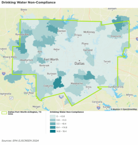
Drinking Water Non-Compliance
Environmental Health
Environmental Health is about more than clean air and water—it’s about designing surroundings that support wellness at every level. From the safety of our homes to the conditions in our workplaces, the environments we live in shape our physical and emotional health every day. When people have access to green spaces, nutritious food, safe housing, and toxin-free communities, they are more likely to experience better sleep, improved cardiovascular health, and reduced stress.
Elevated cancer rates have been linked to environmental contamination.

The Social Vulnerability Index (SoVI) measures a community’s susceptibility to environmental hazards and its capacity to prepare for, respond to, and recover from them. In the DFW area, SoVI highlights how social and economic factors, such as housing, income, and access to resources, intersect with environmental risk.
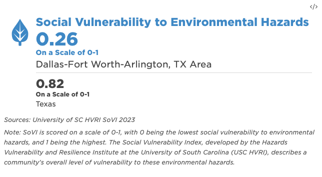
Follow the thumbnail to show the social vulnerability to Environmental Hazards with Dallas-Fort Worth Metropolitan. You can toggle between maps and mouse over regions to view social vulnerability of places (cities), neighborhoods, zip codes and census tracks.
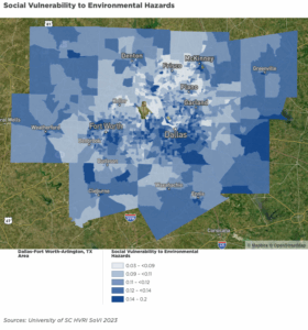
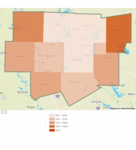
Ozone Environmental Justice Index (by County)
The Ozone Environmental Justice Index reflects the potential burden of ozone pollution on vulnerable populations. It is calculated by multiplying the average summer ozone levels by the proportion of residents who are low-income or belong to racial and ethnic minority groups. Higher index values indicate areas where residents may be more likely to experience disproportionate health impacts from poor air quality.
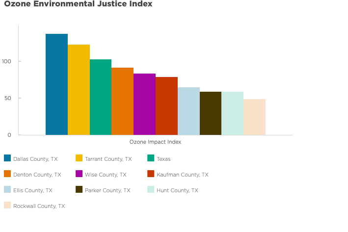
Housing Units With Potential for Lead Paint
Follow the thumbnail to view housing units with potential for lead paint with Dallas-Fort Worth Metropolitan. You can toggle between maps and mouse over regions to view housing units with potential for lead paint of places (cities), neighborhoods, zip codes and census tracks.

Living without access to a park is associated with high blood pressure. Even having a park nearby is related to higher odds of being diagnosed with high blood pressure
Area Dedicated to Parks
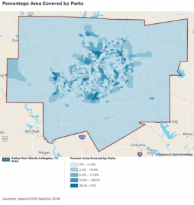
Follow the thumbnail to areas dedicated to parks with Dallas-Fort Worth Metropolitan. You can toggle between maps and mouse over regions to view areas dedicated to parks of places (cities), neighborhoods, zip codes and census tracks.
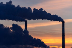
Air pollution plays a big role in many serious diseases. For example:
- About 1 in 4 lung cancer cases are linked to polluted air.
- Around 1 in 6 cases of stroke, heart disease, and lung infections in children are also caused by air pollution.
- For chronic lung diseases like COPD, about 1 in 12 cases are due to air pollution.
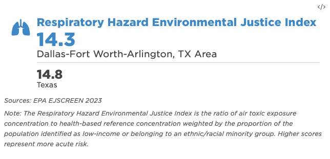
Respiratory Hazard Environmental Justice Index
Did you know? Up to 1 in 4 lung cancer cases can be traced back to air pollution exposure.
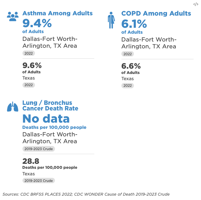
Lung/Bronchus Cancer Death Rate Indicator
Follow the thumbnail to view the Lung/bronchus death rate with Dallas-Fort Worth Metropolitan. You can toggle between maps and mouse over regions to view areas dedicated to parks of counties of DFW and Texas.
The American Lung Association’s 2025 “State of the Air” report indicates that nearly 156 million Americans, approximately 46% of the population live in areas with unhealthy levels of ozone or particulate pollution
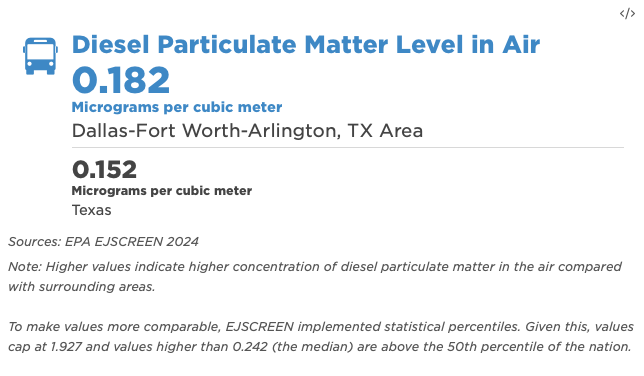
Diesel Particulate Matter Level in Air
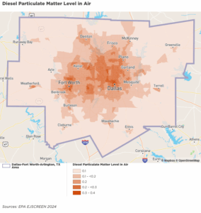
Follow the thumbnail to observe Diesel Particulate Matter Level in Air with Dallas-Fort Worth Metropolitan. You can toggle between maps and mouse over regions to view Diesel Particulate Matter Level in Air of places (cities), neighborhoods, zip codes and census tracks.
Follow the thumbnail to observe Diesel Particulate Matter Level in Air with Dallas-Fort Worth Metropolitan. You can toggle between maps and mouse over regions to view Diesel Particulate Matter Level in Air of places (cities), neighborhoods, zip codes and census tracks.
Natural hazards are extreme events that occur naturally in the environment, such as hurricanes, floods, tornadoes, droughts, wildfires, and extreme heat.
Heat wave “is a period of abnormally and uncomfortably hot and unusually humid weather typically lasting two or more days with temperatures outside the historical averages for a given area” (Source: https://hazards.fema.gov/nri/data-glossary#HeatWave).
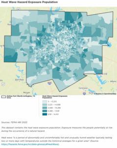
Follow the thumbnail to observe heat wave exposure with Dallas-Fort Worth Metropolitan. You can toggle between maps and mouse over regions to view heat wave exposure of places (cities), neighborhoods, zip codes and census tracks.